|
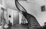
Thornhill Mahogany Staircase
Garret's Shop Topics
First Settlers
Landmarks & Plantations
Snedecor's Directory
Voter Precincts
Overview
1.
Havana
2. New Prospect
3. Five Mile
4. Greensboro
5. Newbern
6. Hollow Square
7. German Creek
8. Forkland
9. Garret's Shop
10. Eutaw
11. Springfield
12. Knoxville
13. Union
14. Pleasant Ridge
15. Mount Hebron
16. Clinton
17. Boligee
Mantua
|
Garret's Shop precinct #9
|
Name, Year Arrived in Greene County Bold - Early
Settler |
Occupation |
Section, Township, Range Precinct of Residence
|
Source
1856 map
1858 map
Directory |
| Akin,
William [From Ireland] |
Planter |
10, 19N,
1E
3, 19N, 1E
4, 19N, 1E |
Dir 1856
1858
1856 1858
1856
1850 Census |
Alpine,
Glen
(William McAlpine 1858) |
|
13, 20N,
1E |
1856 |
| Ashley,
Moses [from SC] |
Overseer |
|
Dir
1850 Census |
|
Avery, Burgess |
Overseer |
|
Dir |
|
Baltzell, Thomas [from Pennsylvania] |
Physician
& Planter |
34, 20N,
1E
27-28, 20N, 1E
33, 20N, 1E
3, 19N, 1E
4-5, 19N, 1E |
Dir 1856
1858
1856 1858
1858
1856 1858
1850 Census |
| Beasley,
Mary |
|
17-19,
19N, 1E |
1856 |
Beazley,
Ptoliver F
Beasley on map |
Planter |
19, 19N, 1E
24, 19N, 1W |
Dir
1856 Estate
1856 Estate |
|
Bernard, John H |
|
21-22,
20N, 1E
20-23, 20N, 1E
15, 20N, 1E
26, 20N, 1E
27, 20N, 1E
27, 20N, 1E
34, 20N, 1E |
1856
1858 Estate
1858 Estate
1858 Estate
1856
1858 Estate
1858 Estate |
| Birchett,
Otway M |
Planter |
29, 20N,
1E
32, 20N, 1E |
Dir 1856
1856 |
|
Bird, Daniel H |
|
1, 20N, 1E
12, 20N, 1E |
1858
1858 |
| Bozeman,
John L |
|
1, 20N,
1E |
1856 |
|
Bragg, D (1818) [David Bragg from Virginia] |
Planter |
28, 20N,
1E
20-21, 20N, 1E
28-29, 20N, 1E
30-31, 20N, 1E
25, 20N, 1W
36, 20N, 1W
14, 19N, 1W
15, 19N, 1W
22-23, 19N, 1W
26, 19N, 1W |
Dir Map
1856 1858
1856 1858
1856
1856
1856
1856
1856 1858
1856 1858
1858
1850 Census |
Bragg,
William (1818)
(from Virginia) |
Planter |
31, 20N,
1E
36, 20N, 1W |
Dir 1856
1856
1850 Census |
|
Braggs, Daniel |
|
20, 20N,
1E |
Map |
Brown, Joshua T
Dir in Boligee |
|
14, 19N,
1W
13, 19N, 1W
23, 19N, 1W |
Dir
1858
1858
1858 |
|
Bullock, James |
|
2-3, 20N,
1E |
1858 |
Bullock, William H
Fair Hill Plantation
Mt. Airy Plantation
[from NC] |
Planter |
14, 20N,
1E
15, 20N, 1E
11, 20N, 1E
28, 20N, 1E
25, 20N, 1W
36, 20N, 1W |
Dir 1856
1858
1856
1858
1856
1856
1856
1850 Census |
Burt, Phillip
Dir in Forkland |
|
29, 20N,
1E
20, 20N, 1E
11-12, 20N, 1E |
1858 Dir
1858
1856 1858 |
|
Charlton, Matilda |
|
20-21,
19N, 1E |
1858 |
Clement, Moses B
Shady Hill Plantation[from Massachusetts] |
Baptist
Minister, Planter |
23, 20N,
1E
26, 20N, 1E |
1856 Dir
1856
1850 Census |
|
Collier, John H [from NC] |
Planter |
2, 19N, 1E |
Dir
1850 Census |
|
Collins, John J |
|
35, 20N,
1E
1-2, 19N, 1E |
1856
1856 |
|
Dallas, Alexander (from Scotland) |
Planter |
18, 19N,
1E
7, 19N, 1E
12-13, 19N, 1W |
Dir 1856
1856
1856
1850 Census |
|
Dallas, William (from Scotland) |
Planter |
|
Dir
1850 Census |
|
Durden, James K (1820) [from SC] |
Planter |
|
Dir
1850 Census |
|
Eubank, John M
maps as Eubanks
[from Alabama] |
Planter |
6, 19N, 1E
5, 19N, 1E
23-24, 19N, 1W
25-26, 19N, 1W |
Dir 1856
1856
1858 Estate
1858 Estate
1850 Census |
|
Exum, Willie |
|
23, 19N,
1W
25-26, 19N, 1W |
1856
Estate
1856 Estate |
|
Garrett, Richard W [from NC] As RWG 36, 20N, 1W Mill
at 11, 19N, 1W |
Planter, Physician and Miller |
9, 19N, 1E
27-28, 20N, 1E
28, 20N, 1E
3-4, 19N, 1E
3-4, 19N, 1E
8-9, 19N, 1E
8-9, 19N, 1E
36, 20N, 1W
1, 19N, 1W
11, 19N, 1W
12, 19N, 1W |
Dir
1858 Estate
1856
1856
1858 Estate
1856
1858 Estate
1858
1856
1856
1856
1850 Census |
|
Glover, A |
|
11, 19N,
1W |
1856
Estate |
|
Glover, Alfred Y |
|
1, 19N, 1E |
1858 |
|
Glover, William A |
|
1, 19N, 1E |
1856 |
|
Gulley, Bryant [from NC] |
Merchant |
20, 20N, 1E
21, 20N, 1E
28-30, 20N, 1E
33, 20N, 1E
24, 20N, 1W
25, 20N, 1W |
Dir
1858
1856 1858
1856 1858
1856 1858
1858
1856 1858
1850 Census |
|
Hairston, R H |
|
19, 20N,
1E |
1858 |
|
Hendrick, Lydia A |
|
1, 19N, 1E |
1856 1858 |
|
Hord, Addison [from Virginia] |
Planter |
24, 19N,
1W
13, 19N, 1W
24, 19N, 1W |
Dir
1856
1856
1850 Census |
|
Hord, Deborah [with Wm on Census, from Virginia] |
|
3-4, 20N,
1E |
1856 1858
1850
Census |
|
Hord, Edward C [from Virginia] |
Planter |
4, 19N, 1E |
Dir
1850 Census |
|
Hord, Edwin G |
|
3-4, 19N,
1E |
1856 |
|
Hord, John H |
Planter |
28, 20N,
1E |
Dir 1856 |
|
Hord, Rhodin [from Virginia] |
Ferry
Keeper |
|
Dir
1850 Census |
|
Inge, William B |
|
12,
19N, 1E |
1858 |
|
Jennings, Thomas K |
Overseer |
|
Dir |
| King,
James [from NC] |
Overseer |
|
Dir
1850
Census |
|
Kirkpatrick, Ann |
|
36,
20N, 1W |
1856 1858 |
|
Knott, William H (1819) [from Virginia] |
Planter |
6, 19N, 1E
31, 20N, 1E
5, 19N, 1E
25, 20N, 1W
26, 20N, 1W
35, 20N, 1W
36, 20N, 1W |
Dir 1856
1858
1856 1858
1858
1858
1858
1858
1858
1850 Census |
| Lay,
Samuel |
Overseer |
|
Dir |
|
Lays, George |
|
19, 20N,
1E |
1856
Estate |
LeBruce, Matilda
(LaBrowse on map)[with Matthew from Fance on census] |
|
5, 19N, 1E |
1858
1850
Census |
|
Little, Holland [from SC] |
Overseer |
|
Dir
1850 Census |
|
Lomona, Bess |
|
24, 20N,
1E |
1856 |
|
Martin, Marius [from France] |
|
24, 19N,
1W
25, 19N, 1W
5, 19N, 1E |
1856 1858
1856
1856
1850
Census |
McAlpine, William
Directory in Forkland |
|
13, 20N,
1E |
Dir 1856
1858 |
| Minor,
Phillip B |
Physician |
|
Dir |
|
Morgan, W W
(person is PENCILED in only!) |
|
6-7, 19N,
1E
18, 19N, 1E
1, 19N, 1W
11, 19N, 1W
2-13, 19N, 1W |
1858
1858
1858
1858
1858 |
Nickels, James
map: James Nichols[from SC] |
Planter |
34, 20N,
1E
35, 20N, 1E
2, 19N, 1E
3, 19N, 1E |
Dir 1858
1856
1856
1856 1858
1850 Census |
|
Nickels, Henry [from SC] |
Overseer |
|
Dir
1850 Census |
| Pace, M B |
Miller |
|
Dir |
|
Perrin, Adeline |
|
13-14,
20N, 1E
23-24, 20N, 1E
25-26, 20N, 1E
34-35, 20N, 1E
1-2, 19N, 1E |
1858
1856 1858
1858
1856 1858
1858 |
|
Perry, Guston |
|
31-32,
20N, 1E |
1858 |
Phares, A J
(is OUTSIDE of Garret's, but clearly marked with a diamond
shape; it COULD be a tiny island in the Tom Bigbee River) |
|
12,
19N, 1E |
1858 |
|
Phillips, Sue |
|
17, 19N,
1E |
1858 |
|
Pierce, William F |
Lawyer,
Planter |
14, 19N,
1W
18-19, 19N, 1E
13, 19N, 1W
15, 19N, 1W
22, 19N, 1W
23, 19N, 1W
24, 19N, 1W |
Dir 1856
1858
1858
1856 1858
1856
1856
1858
|
|
Porter, Theo |
Principal,
Burton's Hill Academy |
|
Dir |
|
Ray, Benjamin F [from Alabama] |
Planter |
31-32, 20N, 1E
25, 20N, 1W
36, 20N, 1W |
Dir
1858
1858
1858
1850 Census |
|
Robinson, Edwin (1820) [from Virginia] |
Planter |
31-32, 20N, 1E |
Dir
1856
1850 Census |
|
Ross, F M |
Carpenter |
|
Dir |
|
Sanford, Daniel F [from Virginia] |
Warehouse
Keeper, Planter |
2, 19N,
1W
31, 20N, 1E
1, 19N, 1W
|
Dir 1856
1858
1856 1858
1856 1858
1850 Census |
Shelton, Richard F
Richard E on maps |
Planter |
34, 20N,
1E
32-33, 20N, 1E |
Dir 1856
1856 1858 |
|
Smith, Patrick |
Planter |
1, 19N, 1W
1, 19N, 1W
6, 19N, 1E
6, 19N, 1E
36, 20N, 1W
36, 20N, 1W |
Dir 1856
1858 Estate
1856
1858 Estate
1856
1858 Estate |
Sorsby, Stephen S
The Grove Plantation[from NC] |
Warehouse
Keeper, planter |
11, 19N,
1E
12, 19N, 1E
14, 19N, 1E
|
Dir 1856
1856
1856
Map, 1850 Census |
Sorsby, Nicholas T
Chestnut Grove Plantation |
Physician,
Planter |
2, 19N, 1E
3, 19N, 1E
10, 19N, 1E
11, 19N, 1E
12-15, 19N, 1E |
Dir 1856
1856
1856
1858
1858 |
|
Sorsby, Thomas J [from NC] |
Planter |
9, 19N, 1E
4, 19N, 1E
10, 19N, 1E
15, 19N, 1E
29-30, 19N, 1E
21, 19N, 1E
22, 19N, 1E
|
Dir 1856
1858
1858
1856 1858
1856
1858
1856
1856 1858
1850 Census |
|
Taylor, Robert [from Ireland] |
Planter |
17, 19N,
1E
18, 19N, 1E
7-8, 19N, 1E
19, 19N, 1E
20, 19N, 1E |
Dir 1856
1858
1856 1858
1856 1858
1858
1856 1858
1850 Census |
|
Thornton, James I
Thornton Hill Plantation
Dir in Forkland
|
|
25-26,
20N, 1E
1, 19N, 1E
35, 20N, 1E
|
Dir 1856
1858
1856 1858
1858 |
|
Tucker, Robert A |
Planter |
13, 19N, 1W |
Dir
1856 1858 |
|
Vue, Bette |
|
12, 20N,
1E |
1856 |
|
Williams, Peter E |
Planter |
10-11, 19N 1W
12-15, 19N, 1W |
Dir
1856 1858
1856 1858 |
|
Willis, George |
|
24, 20N,
1E
24, 20N, 1E
26-27, 20N, 1E
26-27, 20N, 1E
34, 20N, 1E
34, 20N, 1E
1, 19N, 1E
1, 19N, 1E |
1856
1858 Estate
1856
1858 Estate
1856
1858 Estate
1856
1858 Estate |
|
Other entries: |
|
Barton's Hill (spelled Burton in Directory)
|
See Theo
Porter |
13, 20N,
1E |
1856 |
|
Bluff Port
|
|
26, 19N
1W |
1856 |
|
Bragg's Bluff
|
|
12,
19N, 1W |
1856 |
|
C C A M
|
|
32, 20N,
1E
5, 19N, 1E |
1856
1856 |
|
Church
|
|
13, 20N,
1E |
1856 |
|
Church
|
|
9, 19N, 1E |
1856 |
|
Darden's Ferry on Stephen S Sorsby's land
|
|
12, 19N,
1E |
1856 |
|
Garret's Shop
on Richard W Garret property
|
|
9, 19N, 1E |
1856 |
|
Graveyard
|
|
22, 20N,
1E |
1856 |
|
Greenwood; probable Plantation name for Richard W Garret
|
|
9, 19N, 1E |
1856 |
|
Hydro Vist???? on Peter E William's land
|
|
10-11,
19N, 1W |
1856 |
|
Porter's School
|
|
13, 20N,
1E |
1856 |
|
Public Schools |
|
16, 19N,
1E |
1856 1858 |
|
R & K (see 1858 possibly Ray and Knott)
|
|
25, 20N,
1W |
1856 |
Sanford Poorhouse
see Daniel F Sanford
|
|
1, 19N,
1W |
1856 |
|
School
|
|
31, 20N,
1E |
1856 |
|
Warehouse on Stephen S Sorsby land
|
|
12, 19N,
1E |
1856 |
NOTE: BOLD land entry indicates
property is on the Tom Bigbee River
References:
V. Gayle Snedecor, Snedecor's Greene
County Directory 1855-1856, Snedecor's 1856 and 1858 maps. View
Snedecor's maps at the
University of Alabama, Historical Maps collection.
The
Bureau of
Land Management is a great resource for untangling the
Township/Range/Section references.
|